-
Posted: March 06, 2023Categories: General Interest
-
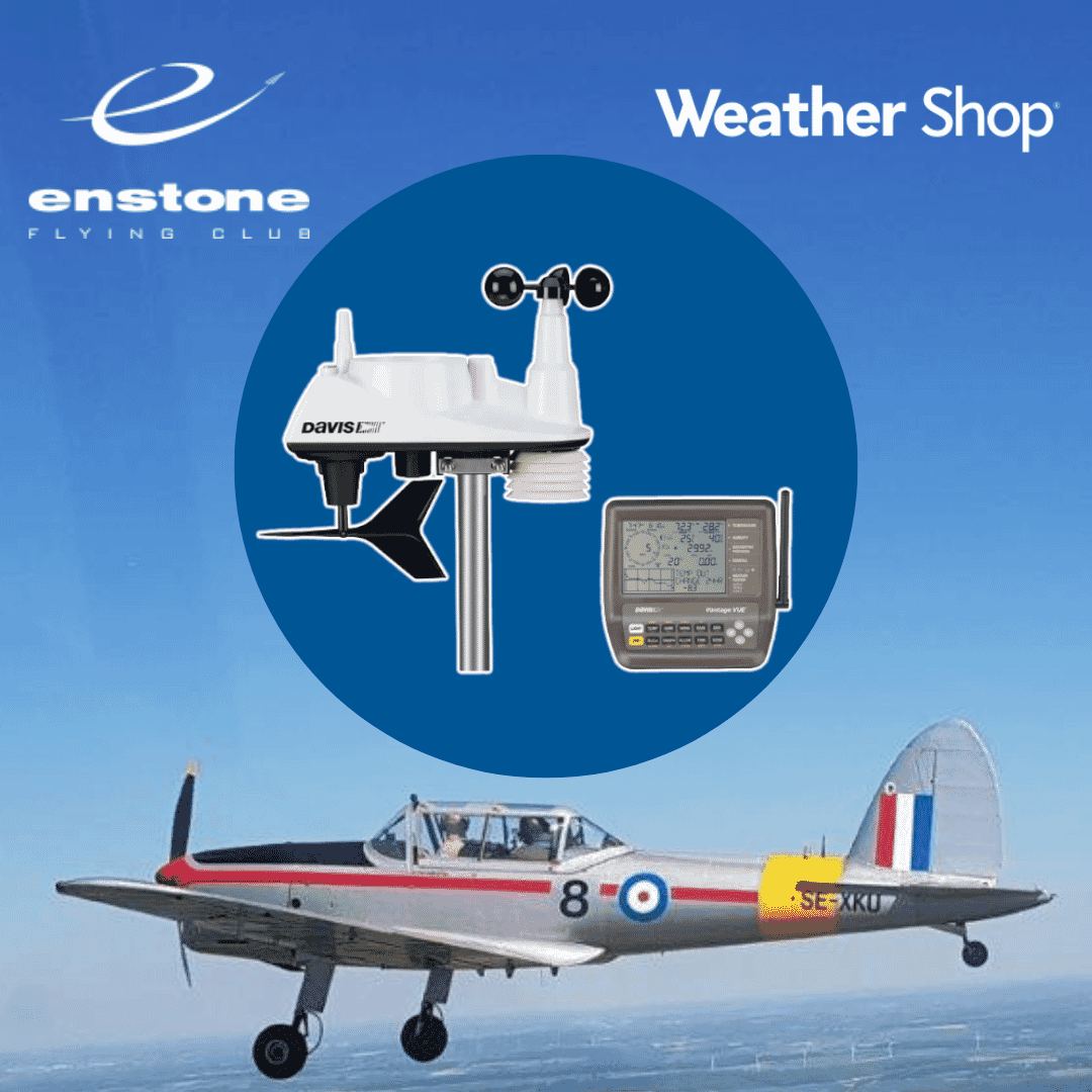
Posted: October 27, 2022
 Read more »
Since pre-historic periods men and women have looked to the sky and wondered what the weather was going to do - perhaps for planned hunting trip or drying pelts gathered from such a trip. Originally it was assumed that the sun ruled the earth’s weather and it was therefore worshipped as a god. Of course in many ways, arguably, we now know that premise to be more or less correct. It is worth remembering that during much of the Bronze Age period climatic conditions in the UK and Europe as a whole were much warmer than those we currently experience, allowing expansion and exploration northwards, although this trend was reversed during much of the cooler Iron Age period.
As soon as mankind adopted an agrarian lifestyle however, having some understanding of the patterns of the weather became essential for crop cultivation. If the crops failed because of drought or flooding, then the villagers would starve. In fact we know that as early as about
-
Posted: December 20, 2017Read more »
Firstly, to cover off measuring the actual depth of snow. By far the simplest method is to use a ruler! Remember that its just an indication of how much snow is on the ground, not how much snow has actually fallen, much may have melted or sublimated (evaporated, which can occur in very dry, sunny or windy conditions). Find a flat area (such as your lawn) away from drifts or any obstacle likely to have caused an obstruction to falling snow; even trees and bushes 2-3 metres away can create areas of uneven depth, especially when it has been windy. We measure to the nearest cm and report the snow depth at least once a day, at 09Z, if possible.
The amount of snow can also be measured by what is known as its 'water equivalent'. The problem is that unless you've got a heated rain gauge (and the UK Met Office does use these), any snow will not drip through into the tipping bucket mechanism either at all or at the time corresponding to that in which in fell in, unless it is very wet. If too
-
Posted: November 22, 2017Read more »
We learn to live with the weather from almost as soon as we are born. It affects our moods, our health, our work and indeed the relationships we have with others. It is worth understanding a little more about the topic simply because there is little else that has so much of an impact on our everyday lives. We may try and shut it out, create our own micro climates: central heating, air conditioning and double glazing but one way or the other it is likely to affect us. The price we pay for our consumer services is very often in some way dictated, to a greater or lesser extent, by what the weather has been doing in the past month. With the greater emphasis we now place in the 21st century on understanding climatic change and the influence that this also has on our society, there has never been a better time to understand something of the basics of the science of meteorology; the weather.
The definition of the science of the weather
-
Posted: November 21, 2017Categories: General InterestRead more »
As could be seen in part two of this potted history, the Admiralty was reasonably well prepared for the onset of hostilities. Four years previously, in 1935, documents were produced authorising aircraft carriers, battleships and larger cruisers to be equipped according to their status and advising on the location of the Met Office and balloon shelter; also the siting of certain crucial, and delicate, meteorological instruments in order that they were able to function in the desired manner.
As could be seen in part two of this potted history, the Admiralty was reasonably well prepared for the onset of hostilities. Four years previously, in 1935, documents were produced authorising aircraft carriers, battleships and larger cruisers to be equipped according to their status and advising on the location of the Met Office and balloon shelter; also the siting of certain crucial, and delicate, meteorological instruments in order that they were able to function
-
Posted: November 20, 2017Categories: General InterestRead more »
The meteorologist’s skills as used during WW1 must have been of use, particularly to the Royal Navy aviation world as once hostilities ceased, for those officers who had a particular interest in the weather; cessation did not appear to be an option. Although the majority of their work was done, these intrepid future RN Forecasters continued using their knowledge alongside their other duties on board ship.
At this time it did not really occur to anyone that these skills could be transferred to the shore bases where a few planes were still based. True most of the aerodromes had been transferred to the newly formed Royal Air Force, but now that the Naval Air Service (NAS) had disbanded, Royal Naval Air Stations (RNAS) were beginning to come into being, after all aircraft carriers were beginning to come into their own and when the ships were not at sea or were being refitted it was necessary to store the planes somewhere. Most of these stores were part of
-
Posted: October 24, 2017Categories: General InterestRead more »
Despite the fact that we are an island race who have been reliant upon ships to leave these shores from time immemorial and, more importantly, have needed ships and some sort of navy to repel the invading hoards; meteorology and the Royal Navy have been seriously linked together for less than two hundred years. In fact the RN has had its own meteorological branch for just short of one hundred years. Through a series of articles it is hoped to reveal some of this fascinating history for the very first time.
For many years weather was recorded in the Captain's log book every day the individual ship was at sea. This was not just military ships but merchantmen as well. Where did the knowledge come from and what was the training? The answer is simple, the only training was a lifetime’s experience of being at sea and building up the ability to recognise certain signs and situations and the effect they had upon the ensuing weather. Instruments for reading,
-
Posted: August 17, 2017Read more »
One of the most important things anyone wanting to understand the weather can learn is how to recognise the salient features shown on a weather map.
The first thing a meteorologist will draw up on his or her chart (although nowadays nearly all maps are generated automatically by computers) are lines of equal pressure from observations. These are usually in millibars (mb) or sometimes inches.
We call lines joining points of equal pressure isobars. They are helpful because by creating them we can start to identify areas of high and low pressure at both the surface and aloft, that control our weather pattern. Pressure values are generally corrected to Mean Sea Level Pressure (MSLP) so that a standardised level can be shown, otherwise the observers height would affect the readings, as pressure decreases with altitude quite substantially.
The chart below shows a map with pressure readings taken from
-
Posted: August 16, 2017Read more »
Last month we talked about some of the ways to get forecast weather information of specific use to the marine community. As I mentioned then though, if you know your met well enough then you'll be able to supplement the forecast with information on the hoof, interpreting changes to the weather as you go along.
What then are some of the signs that can warn you in advance of the imminent development of stormy weather, that for smaller craft and crew can cause the most problems?
Generally, sea and swell will take their time to rise and you can usually be aware of these changes enough in advance to head for port. However the most rapid changes usually occur when atmospheric conditions cause sudden squalls and thunderstorms. These are often linked to frontal passages and again, a quick check on the forecast weather chart will usually show if you are likely to encounter them on your journey. A cold front in particular will often give squalls and heavy
-
Posted: May 03, 2017Categories: General InterestRead more »
One way to observe the South Downs Way is to walk along part, or if you're feeling brave, all of it. In good summer weather with plenty of long hours of light, this is an excellent way to completely immerse yourself in another way of life for a week. Forget the jet set, I'm talking about the sturdy boots set here!
The walk covers 100 miles in all from Winchesrer to Eastbourne with about 4150 m (13600 feet) of hills to climb and ascend whichever way you travel. It takes about 8 days to walk it (3 to cycle it) and you will climb as high as Butser Hill in Hampshire to 270m (900ft) and also Ditchling Beacon (East Sussex) at 248m (814ft).
You will mainly be walking on well maintained wide grassy or flinty tracks across the chalk downland, grazed by sheep on the hills with arable crops below; whilst the western part of the Downs tends to be composed of rolling farmland, the mid section of the West Sussex Downs are dominated by steep, sometimes wooded escarpments with good views